Geonetwork - Test
Administrative inndelinger REST-API
API for oppslag mot datasettet administrative inndelinger, -fylkesinndeling og kommuneinndeling.
Spørring skjer mot en distribusjonsdatabase av administrative inndelinger som oppdateres ved behov.
API-et er åpent og fritt tilgjengelig. Det er dokumentert ved bruk av OpenAPI-standarden og et Swagger grensesnitt. API-et egner seg ikke for å hente ut komplette datasett. Hvis man ønsker å hente ned større datasett så anbefales det å laste ned filene som er tilgjengeliggjort via geonorge.no.
De som trenger testdata for 2024 kan benytte denne URLen: https://api.test.kartverket.no/kommuneinfo/v1/
Simple
Identification info
- Date (Creation)
- 2019-01-04
- Date (Publication)
- 2019-01-04
- Date (Revision)
- 2019-01-04
- Purpose
-
Formålet med tjenesten er å gi enkel tilgang til administrative inndelinger
- Status
- Historical archive
- Point of contact
-
Organisation name Individual name Electronic mail address Role Norwegian Mapping Authority
Kundesenter
Publisher Norwegian Mapping Authority
Carina Tolpinrud Jøntvedt
Owner
- Maintenance and update frequency
- As needed
- GEMET - INSPIRE themes, version 1.0
-
-
Administrative enheter
-
- Nasjonal inndeling i geografiske initiativ og SDI-er
-
-
dataNorgeNo
-
Felles datakatalog
-
- Nasjonal tematisk inndeling (DOK-kategori)
-
-
Basis geodata
-
-
COMMISSION REGULATION (EC) No 1205/2008 of 3 December 2008 implementing Directive 2007/2/EC of the European Parliament and of the Council as regards metadata, Part D 4, Classification of Spatial Data Services
- Keywords
-
-
Kommune
-
Fylke
-
- Specific usage
-
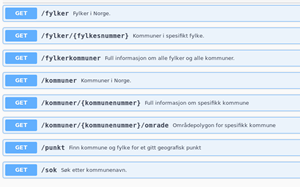
Hente ut enkel informasjon om fylke og kommune. f.eks kommunenummer, kommunenavn og område (polygon).
For eksempel: Finn kommune eller fylke for et gitt punkt, finn kommunenummer ved å søke på kommunenavnet eller finn nabokommuner til en kommune.
- User contact info
-
Organisation name Individual name Electronic mail address Role Owner
- Access constraints
- Other restrictions
- Other constraints
- Åpne data
- Use constraints
- Other restrictions
- Other constraints
- No conditions apply to access and use
- Classification
- Unclassified
- Service Type
- other
- Ordering instructions
))
- Coupling Type
- Tight
- Contains Operations
-
Operation Name Distributed Computing Platforms Connect Point
- Distribution format
-
Name Version JSON
0
- OnLine resource
-
Protocol Linkage Name W3C:REST
https://ws.geonorge.no/kommuneinfo/v1/
- Hierarchy level
- Service
- Other
-
service
Metadata
- File identifier
- 3fcce35c-759b-4c6e-adb9-f03478c6fb72 XML
- Metadata language
- Norwegian
- Hierarchy level
- Service
- Hierarchy level name
-
service
- Date stamp
- 2024-09-16
- Metadata standard name
-
ISO19115
- Metadata standard version
-
2003
- Metadata author
-
Organisation name Individual name Electronic mail address Role Norwegian Mapping Authority
Kundesenter
Point of contact