 Geonetwork - Test
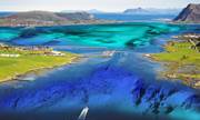
Hydrographic survey data
Hydrographic survey data is the most detailed depth data that the Norwegian Mapping Authority, Hydrographic Service has. This data has been collected by mapping the seabed in Norwegian coastal and sea areas.
Detailed depth data for large areas of the coast has been gathered using multibeam echo sounders. Only older surveys with less detailed resolution are available for other areas. Older data is being replaced regularly as new data is collected.
Hydrographic survey data includes several types of depth information. The main products are point data with position and depth (.xyz), in addition to log data (.all). For more recent surveys, log data containing backscatter information and water column data (.wcd) is also available.
Simple
- Date (Revision)
- 2017-10-05
- Date (Creation)
- 2015-01-12
- Date (Publication)
- 2015-01-12
- Code
- dybdedata_raadata
- Purpose
-
These data are used as basis for the Norwegian Hydrographic Service's digital and analog chart products and are very detailed. Data inside the territorial limit of 12 nautical miles are subject to military restrictions. This means that data more dense than 50x50 meter between the nodes are defined as classified information in coastal areas.
- Status
- On going
- Point of contact
-
Organisation name Individual name Electronic mail address Role Kartverket
Kartverket FMT-Sjø
Point of contact Norwegian Mapping Authority
Publisher Norwegian Mapping Authority
Owner
- Maintenance and update frequency
- Continual
- GEMET - INSPIRE themes, version 1.0
-
-
Havområder
-
- Nasjonal inndeling i geografiske initiativ og SDI-er
-
-
Norway Digital
-
Mareano
-
Modellbaserte vegprosjekter
-
Felles datakatalog
-
- Nasjonal tematisk inndeling (DOK-kategori)
-
-
Kyst og fiskeri
-
- Place
-
-
Norway's inner coastal waters
-
Svalbard's inner coastal waters
-
Barents Sea
-
Norwegian Sea
-
North Sea
-
Skagerrak
-
- Theme
-
-
sea
-
soundings
-
survey data
-
original hydrographic chart
-
banks, shoals, shallows
-
underwater rocks
-
coast
-
MAREANO
-
- Keywords
-
-
Norwegian Mapping Authority, Hydrographic Service
-
- Specific usage
-
Routing for submarine cables, pipelines, subsea tunnels, etc. development in sea areas or the coastal zone. Different types of thematic map. Petroleum activity. Modelling of sea currents, sea level rise, marine contamination, etc. Fishing and aquaculture. Mapping of seabed conditions, marine vegetation, conservation areas, etc. Emergency response, search and rescue. Archaeological surveys. Please send an email to sjodata@kartverket.no for all communication and to order hydrographic survey data.
- User contact info
-
Organisation name Individual name Electronic mail address Role Owner
- Use limitation
-
The data is not approved for navigational purposes. Data inside the territorial limit of 12 nautical miles are subject to military restrictions. This means that data more dense than 50x50 meter between the nodes are defined as classified information in coastal areas.
- Access constraints
- Other restrictions
- Other constraints
- Skjermede data
- Use constraints
- Other restrictions
- Other constraints
- Creative Commons BY 4.0 (CC BY 4.0)
- Other constraints
-
Interested parties can send a request to the Norwegian Hydrographic Service for release of hydrographical survey data by e-mail to sjodata@kartverket.no.
- Classification
- Confidential
- Spatial representation type
- Vector
- Denominator
- 5000
- Language
- Norwegian
- Topic category
-
- Oceans
))
- Supplemental Information
-
Internet pages for this type of data: https://www.kartverket.no/en/data/kartdataer/Marine-Geospatial-Data/Hydrographic-Survey-Data/ and https://www.kartverket.no/en/data/kartdataer/Marine-Geospatial-Data/Marine-Primary-Data/
Contact information: sjodata@kartverket.no, tel.: (+47) 32 11 80 00
- Unique resource identifier
- EPSG:4326
Spatial representation info
- Distribution format
-
Name Version ASCII x,y,z
Distributor
- Distributor contact
-
Organisation name Individual name Electronic mail address Role Kartverket
Kartverket FMT-Sjø
Distributor
- Distributor format
-
Name Version SOSI v3.2
shape
xyz
papir
- OnLine resource
-
Protocol Linkage Name GEONORGE:OFFLINE
https://wms.geonorge.no/skwms1/wms.dekning_sjomaaling?
- Hierarchy level
- Dataset
Completeness omission
- Name of measure
- Prosentvis oppfyllelse av FAIR-prinsipper
- Measure description
-
Angir fullstendighet i forhold til krav fra FAIR-prinsippene (The FAIR Guiding Principles for scientific data management and stewardship)
Quantitative result
- Value
- 63
- Statement
-
In the case of modern data collected using multibeam echo sounders, the resolution will vary between 1m x 1m grids close to the coast for more recent surveys, or, as point data, with even higher resolution. Modern surveys that are slightly older, or were carried out in deeper waters, will frequently have a slightly lower resolution, typically from 3m x 3m to 10m x 10m. For older data collected using equipment such as single beam echo sounders, hand lead or machine lead, the resolution will typically be 20-50m between each recorded depth point in shallow, coastal areas. The resolution is even lower in the middle of fjords.
Metadata
- File identifier
- 2fe7b56c-334d-4660-ac50-6fcf973a0f70 XML
- Metadata language
- Norwegian
- Hierarchy level
- Dataset
- Date stamp
- 2025-01-14
- Metadata standard name
-
ISO19115
- Metadata standard version
-
2003
- Metadata author
-
Organisation name Individual name Electronic mail address Role Norwegian Mapping Authority
Point of contact
- Other language
-
Language Character encoding English UTF8


)))
