 Geonetwork - Test
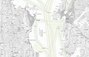
Maritime transport - main and secondary fairways - area delineation
Fairways are indicated through the Regulation on fairways.
The entire coast of Norway is currently covered by a standardised reference system of various fairway categories. The fairway structure includes the network of maritime transport arteries and is a national geographical reference system for measures within administration, planning, development and operational activities in the coastal zone.
More about the fairway structure:
http://www.kystverket.no/Maritim-infrastruktur/Farleder/Farledsstrukturen/
The dataset shows the extent of the main and secondary fairway in terms of area.
Simple
- Date (Publication)
- 2009-11-30
- Date (Creation)
- 2020-01-01
- Date (Revision)
- 2025-02-05
- Purpose
-
The fairway dataset describes where the Norwegian Coastal Administration's main areas of interest are. It is important for the Norwegian Coastal Administration to ensure that the network of fairways is taken into account during planning and administration in coastal areas.
- Status
- Completed
- Point of contact
-
Organisation name Individual name Electronic mail address Role Kystverket
Simen Slotta
Point of contact The Norwegian Coastal Administration
Kystverket / Geodatatjenesten
Publisher The Norwegian Coastal Administration
Kystverket / Geodatatjenesten
Owner Kystverket
Simen Slotta
Owner Kystverket
Simen Slotta
Owner Kystverket
Simen Slotta
Owner Kystverket
Simen Slotta
Owner Kystverket
Simen Slotta
Owner Kystverket
Simen Slotta
Owner
- Maintenance and update frequency
- Irregular
- GEMET - INSPIRE themes, version 1.0
-
-
Transportnett
-
- Nasjonal inndeling i geografiske initiativ og SDI-er
-
-
Beredskapsbase
-
NSDI data
-
Norway Digital
-
Geodata Act
-
Felles datakatalog
-
- Nasjonal tematisk inndeling (DOK-kategori)
-
-
Samferdsel
-
- Place
-
-
Norway
-
coast
-
- Theme
-
-
fairway area delimitation
-
main fairway
-
secondary fairway
-
Norwegian Coastal Administration
-
regulations on fairways
-
fairways
-
- Specific usage
-
The fairway dataset describes where the Norwegian Coastal Administration's main areas
of interest are on the coast, and it is important for the Norwegian Coastal Administration to ensure that the network of fairways is taken into account during planning and administration in coastal areas.
The areas show the extent of the main and secondary watercourses in terms of area.
- User contact info
-
Organisation name Individual name Electronic mail address Role Owner
- Use limitation
- No conditions apply
- Access constraints
- Other restrictions
- Other constraints
- Åpne data
- Use constraints
- Other restrictions
- Other constraints
- Norsk lisens for offentlige data (NLOD) 2.0
- Other constraints
-
Ingen begrensninger oppgitt.
- Classification
- Unclassified
- Spatial representation type
- Vector
- Denominator
- 50000
- Language
- Norwegian
- Topic category
-
- Oceans
))
- Begin date
- 2020-01-01
- Supplemental Information
-
The dataset is established on a scale of 1: 50,000.
- Unique resource identifier
- EPSG:25832
- Unique resource identifier
- EPSG:25833
- Unique resource identifier
- EPSG:25835
- Unique resource identifier
- EPSG:3035
- Distribution format
-
Name Version FGDB
FGDB
10.0
GML
GML
3.2.1
PostGIS
PostGIS
12
SOSI
SOSI
4.5
SOSI
4.5
Shape
1.0
FGDB
10.3
GML
3.2.1
KML
2.2
GeoJSON
1.0
FGDB
GML
PostGIS
SOSI
Distributor
- Distributor contact
-
Organisation name Individual name Electronic mail address Role Kystverket
Simen Slotta
Distributor
- Distributor format
-
Name Version SHAPE
SOSI
- Units of distribution
-
fylkesvis, kommunevis, landsfiler
- OnLine resource
-
Protocol Linkage Name GEONORGE:DOWNLOAD
https://nedlasting.test.geonorge.no/api/capabilities/
- Hierarchy level
- Dataset
Domain consistency
Conformance result
- Title
-
SOSI-produktspesifikasjon: Farled
- Date (Publication)
- 2015-11-17
- Title
-
sosi
- Date
- Explanation
-
The data is according to the product specification
- Pass
- Yes
Conformance result
- Title
-
Sosi applikasjonsskjema
- Date (Publication)
- 2015-11-17
- Title
-
uml-sosi
- Date
- Explanation
-
SOSI files are according to application form
- Pass
- Yes
Conformance result
- Title
-
Sosi applikasjonsskjema
- Date (Publication)
- 2015-11-17
- Title
-
uml-gml
- Date
- Explanation
-
GML files are according to application form
- Pass
- Yes
Completeness omission
- Name of measure
- Prosentvis oppfyllelse av FAIR-prinsipper
- Measure description
-
Angir fullstendighet i forhold til krav fra FAIR-prinsippene (The FAIR Guiding Principles for scientific data management and stewardship)
Quantitative result
- Value
- 96
Metadata
- File identifier
- 1e8d7811-87ea-429a-8d97-4ea6bbf6e010 XML
- Metadata language
- Norwegian
- Hierarchy level
- Dataset
- Date stamp
- 2025-05-13
- Metadata standard name
-
ISO19115
- Metadata standard version
-
2003
- Metadata author
-
Organisation name Individual name Electronic mail address Role The Norwegian Coastal Administration
Kystverket / Geodatatjenesten
Point of contact
- Other language
-
Language Character encoding English UTF8


)))
